

Take the Trail
Start opposite the Piccadilly Cinema on O’Connell Street North Adelaide.
This Trail is on the traditional land of the Kaurna people.
1. Introduction
2. Naming of Park 3
3. Native vegetation and biodiversity in Park 3
4. Naming of (and entrance to) Park 5
5. Medindie Mansions overlooking Park 5
6. North Adelaide Dog Park in Park 5
7. Significant trees in Park 5
8. Re-alignment of Le Fevre Road between Parks 4 and 5; and native vegetation
9. Naming of Park 4; and Park Lands trail
10. Carbon offset planting
11. Two former sporting ovals in Park 4
12. Electricity substation in Park 4
13. An Underground Reservoir in Park 4
14. Pine trees and bicycle path in Park 4

Start this trail opposite the Picadilly Cinema near the corner of O’Connell Street and Barton Terrace East. There are 14 stops on this Trail and it will take about 90 minutes to complete. Walking instructions are designated by bold type at the end of each of the 14 stop descriptions.
Optional: download and print a tri-fold leaflet, i.e. a double-sided single A4 page, with a brief summary of this Trail Guide: (PDF, 4.1 Mb)

1. Introduction
Canary Island Pine trees in Reservoir Park / Kangatilla (Park 4) at the start of the North Adelaide Park Lands tour
This trail takes in three of the smaller Parks on the northern fringes of the Adelaide Park Lands. The three parks are:
• Yam Daisy Park / Kantarilla (Park 3)
• Reservoir Park / Kangatilla (Park 4) and
• Bragg Park / Ngampa Yarta, (Park 5)
Taken together these three Parks represent just over two per cent of the entire area of the Park Lands. They are 16 hectares, combined, in total. By contrast, the large Park 6 nearby – where the horses are depastured is a large 42 hectares – more than twice the size of these three combined.
This trail starts at the corner of O’Connell Street and Barton Terrace East – opposite the Piccadilly Cinema.
The trail is approximately 2.4 kilometres. It will take about 50 minutes walking, longer of course if you stop and look about at various points.
Before leaving this spot, take a look at the large trees along the edge of O’Connell Street. These are Canary Island pine trees, probably planted between the 1920’s and 1930’s – so close to 100 years old.
From this point, head north alongside the Canary Island Pine Trees, until you get to the traffic lights, where you cross Main North Road into Park 3.
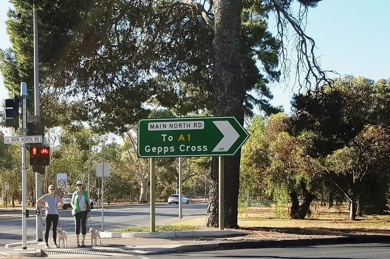
The southern tip of Yam Daisy Park / Kantarilla (Park 3)
After crossing Main North Road, you are at the southern tip of a triangular-shaped Park - Yam Daisy Park / Kantarilla (Park 3).
Park 3 is is the smallest of the three Parks in this trail. It is only 3.2 hectares, but it’s NOT the smallest of all the Parks in the Adelaide Park Lands. That honour belongs to Park 28 (Palmer Gardens) which is only 1.8 ha. However Park 3 is the second-smallest of all the Parks.
The name Kantarilla takes its origin from the Kandara, a native plant with a yellow flower, and edible roots like a radish or yam, formerly a food source for the Kaurna people. So its English name and its Kaurna name mean the same thing. Kantarilla means the Yam Daisy plant. See if you can see one!
Along with the adjacent Parks 4 and 5, Kantarilla (Park 3) is one of the few designated off-leash areas in the Park Lands for dog exercise.
Like much of the northern Parks, vegetation here was cleared in the early years of European settlement after 1840, and a program of re-planting had to be undertaken in later decades.
The tree on the southern tip of Park 3 – right next to the traffic lights - is an Aleppo Pine. It is the same species as the famous “lone pine” at Gallipoli. It was planted more than 100 years ago, but these days in South Australia this species is a declared noxious weed!
A little further along off Prospect Rd is another Canary Island Pine, like those along O’Connell St.
Head north, into the Park, walking through the open scrub land between Prospect Road and Main North Road.
Stop somewhere in the bush. Pause, and feel the serenity.

2. Yam Daisy Park / Kantarilla (Park 3)
Yam Daisy / Murnong / Microseris sp.
After crossing Main North Road, you are at the southern tip of a triangular-shaped Park - Yam Daisy Park / Kantarilla (Park 3).
Park 3 is is the smallest of the three Parks in this trail. It is only 3.2 hectares, but it’s NOT the smallest of all the Parks in the Adelaide Park Lands. That honour belongs to Park 28 (Palmer Gardens) which is only 1.8 ha. However Park 3 is the second-smallest of all the Parks.
The name Kantarilla takes its origin from the Kandara, a native plant with a yellow flower, and edible roots like a radish or yam, formerly a food source for the Kaurna people. So its English name and its Kaurna name mean the same thing. Kantarilla means the Yam Daisy plant. See if you can see one!
Along with the adjacent Parks 4 and 5, Kantarilla (Park 3) is one of the few designated off-leash areas in the Park Lands for dog exercise.
Like much of the northern Parks, vegetation here was cleared in the early years of European settlement after 1840, and a program of re-planting had to be undertaken in later decades.
The tree on the southern tip of Park 3 – right next to the traffic lights - is an Aleppo Pine. It is the same species as the famous “lone pine” at Gallipoli. It was planted more than 100 years ago, but these days in South Australia this species is a declared noxious weed!
A little further along off Prospect Rd is another Canary Island Pine, like those along O’Connell St.
Head north, into the Park, walking through the open scrub land between Prospect Road and Main North Road.
Stop somewhere in the bush, pause, and feel the serenity.

Yam Daisy Murnong /Microseries sp. is a tuberous native yam which has a distinct nutty-taste when roasted, and was a staple food source for many Aboriginal communities across southern Australia

3. Native vegetation in Park 3
In recent times, there’s been research suggesting health benefits from spending time in nature away from the constant noise and ‘busyness’ of modern life. In Japan, it’s known as “forest bathing”. Few people would realise that a perfect location for this relaxation and meditation can be found just a few minutes from the city.
Yam Daisy Park / Kantarilla (Park 3) contains no special facilities except a drinking fountain, two park benches and a dog poo bag dispenser. Apart from a mighty English elm tree in the north-west corner, and two very large pines (the Canary Island Pine and the Aleppo Pine) near O'Connell Street, most of the native vegetation in this Park is limited in size due to the mainly shallow soil over a limestone base.
There are golden wattle, and white bottle-brush shrubs here. Lizards, spiders and sometimes birds find their homes here. The logs are left for habitat for all the different animals and creatures that live in a space like this.

Callistemon citrinus 'White Anzac' in Yam Daisy Park /Kantarilla (Park 3) between Prospect Rd and Main North Rd
The Park Lands Management Strategy endorsed in 2016 by the City Council envisages “Improving the accessibility, amenity and safety of Park 3 as a medium priority”. To that end, there’s a suggestion that (subject to future funding) an “Australian Native Sensory Trail” may be built and signposted in this Park.

Cut log in Yam Daisy Park /Kantarilla (Park 3)
In 2020 the City Council began some work in this Park to install a shared-use bicycle and pedestrian path alongside Prospect Road. Traffic along Prospect Road was reduced to one lane in each direction, to accommodate both the shared-use path and car parking along the roadside. The work was to include more consistent tree planting along the shared-use path.
Walk now to the north-west corner of this Park, to the intersection of Main North Road and Robe Terrace. At the traffic lights, cross over Main North Road which will bring you into Park 5.

English elm tree and park bench in Yam Daisy Park / Kantarilla (Park 3)

4. Naming of Park 5
Bragg Park / Ngampa Yarta, Park 5 is just under 5 hectares in size and represents less than one per cent of the entire Adelaide Park Lands.
Ngampa Yarta is a Kaurna language name. It means “Ngampa root ground”, referring to an edible root that was important to the diet of local Kaurna people. Pre‑colonisation, this area would have been used as a site for camping by the Kaurna people. It lay on several movement and trade routes used by the Kaurna, and would have provided an abundant source of game.
In September 2017 the Adelaide City Council decided to give this Park a second name. As part of a new policy of giving English names to all Parks (in addition to the Kaurna names) they have called this “Bragg Park”.
In Adelaide’s history there have been two famous men both named William Bragg. They were father and son – both physicists – both joint winners of the 1915 Nobel prize for physics (each specializing in X-rays) and both later knighted.
Sir William Henry Bragg was born in England in 1862 and migrated to Adelaide. His son Sir William Lawrence Bragg was born in Adelaide in 1890, but spent most of his career in the UK. The younger Bragg would have been one of the first persons in Adelaide to have had an X-ray, courtesy of his pioneering father, when the younger Bragg had broken his arm, at age 6.
Perhaps he might have broken his arm playing in this very Park?
Earlier on this walk, we saw Canary Island PINE trees along the edge of O’Connell Street.

Canary Island Palm trees on the northern boundary of Bragg Park / Ngampa Yarta (Park 5)
In 1928, an avenue of about 70 Canary Island PALM trees was planted here along Robe Terrace. They’re still here, and you can see they are thickest here, near the corner of Main North Rd.
These Palms became such a well-recognised feature of Park 5 that they survived a road-widening scheme in the year 2000. At the time of the road widening they were transplanted a few metres south to stay alongside the new, wider road.
Just behind the palm trees are two large Aleppo pine trees, one of which is spot-lit at night. Alongside these trees you will see a park bench with a memorial plaque, honouring a woman who came to watch tennis games here. But you cannot see any tennis courts here.
Tennis? Where are the tennis courts?
There is no sign of them anymore, but there were as many as 13 tennis courts here, established in succession over several years starting in 1924.

An aerial photo of 1935 showing the many tennis courts alongside the former alignment of Lefevre Road, especially near the intersection of Main North Road and Robe Terrace.
We have been unable to ascertain when the tennis courts were removed, but it would have been no later than the 1960s, when the route of Lefevre Road was changed.
From this point, walk along the avenue of Canary Island palm trees. Go past all of them until you reach the next road intersection, which is the corner of Medindie Road.

Canary Island Palm trees on the northern boundary of Bragg Park / Ngampa Yarta (Park 5)

5. Medindie Mansions
On the corner of Robe Terrace and Medindie Rd, look across to the two old-style mansions on the other side of Robe Terrace. Each of these two large houses has a unique story.
Unlike in the eastern States, most of the 19th century gentry of South Australia chose to build their mansions close to the city rather than on rural estates. Some of these mansions represent the vast fortunes that could be built in the early days of the South Australian colony.
The mansion on the right was built by Charles Rasp. Mr Rasp moved from Stuttgart in Germany to Australia (for his health) in 1869. He worked as a boundary rider at a sheep station in western New South Wales.
One day, while riding, he was struck by the appearance of a so‑called “broken hill” and returned to stake out a claim in 1883. Rather than the hoped-for tin, the “broken hill” turned out to be full of silver.
Within five years of staking his claim, Rasp was rich, and moved to Adelaide to build his mansion, which you can see on the right. The syndicate he formed became BHP, now one of the largest mining companies in the world.

One of the Medindie mansions overlooking Bragg Park / Ngampa Yarta (Park 5)
The distinctive red turreted mansion to the left was built in 1898 for Fredrick George Scarfe, former director of the Harris Scarfe department store. In 1905 Fredrick Scarfe who was unsatisfied with the aesthetics of his drive to work, donated 25 pounds to the council for the planting of elm trees along Medindie Road.
Two thousand local school children were employed to the task, and were rewarded with half a day off school and sweets handed out by Mr Scarfe, for their labours. Today, none of those elm trees remain, although there are many English elm trees in other parts of the Park Lands.
Legend has it that in the 1920s, a young lady tragically died in Mr Scarfe’s house. She supposedly continues to haunt the house to this day.
From the corner of Robe Terrace and Medindie Road, walk south along Medindie Road about 100 metres to a dirt track on your right.

6. North Adelaide Dog Park
From the corner of Robe Terrace and Medindie Road, walk south along Medindie Road about 100 metres. On your right you will see a dirt path for pedestrians that leads to the North Adelaide dog park. Go through the gates into one of the two dog park compounds and look around you.
This is an excellent example of how the processes of community engagement, consultation, planning and design can become something more than buzzwords, and actually create flourishing urban communities.
In 2009, a 13-year-old girl from North Adelaide Primary School started collecting signatures to create a fenced-off dog park in North Adelaide. The girl's name was Erin O'Brien. She got the idea because she had a friend, a woman who would regularly drive for almost an hour every night to take her dogs to an off-leash park in another part of town.
After collecting her signatures and presenting the petition to the Adelaide City Council, the Council soon acknowledged this was a good idea. It took 18 months more to make the plans, and consult on the plans.

North Adelaide Dog Park in Bragg Park / Ngampa Yarta (Park 5)
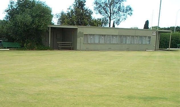
Then some more time elapsed for the actual construction. After Erin's bright idea in 2009 it was in 2012 that the dog park opened. The area used to be two small cricket ovals; but they were not much used and there are plenty of other ovals in other Parks – notably in Park 2 and Park 6 not far away.
The project cost the Council $370,000. The year after it opened, that is in 2013, it was recognised as the best park of its type in Australia. The Parks and Leisure Australia National Awards, gave this Park the national honour for its community engagement and design.
The area is divided into two spaces, one for small dogs and puppies, and the other for larger dogs. The park is equipped with shelters and seating for humans, and tunnels and rally obstacles for dogs.

North Adelaide Dog Park in Bragg Park / Ngampa Yarta (Park 5)
Today, the park is extremely popular, attracting not only locals, but others who make sometimes cross-town trips to use the park. It is a place with a real sense of community, where canines and humans alike can meet and create long-lasting friendships.
It’s so good that it’s been duplicated In October 2017, the City Council opened another dog park, very similar to this, in Pelzer Park / Pityarilla (Park 19) just off Glen Osmond Road near South Terrace.
Leave the dog park by one of the gates on the southern side and walk south, through the bushland, for about 100 metres. Stop, in the scrub, about 50 metres before the road junction of Medindie road and Lefevre Road.

7. Significant trees in Park 5
Standing in-between Medindie Road and Lefevre Road, near the southern end of Park 5, you can see a number of significant trees.
(a) Weeping Myall
Quite close to this point you should be able to see two “Weeping Myall” trees. These trees get their name “weeping” because, like a “weeping willow” tree they have “weeping” or drooping branches. It’s a type of acacia (acacia pendula) native to this area (also native to most of the eastern States) and is drought tolerant. These two specimens are well-established. They would have been planted by City Council gardeners many decades ago.
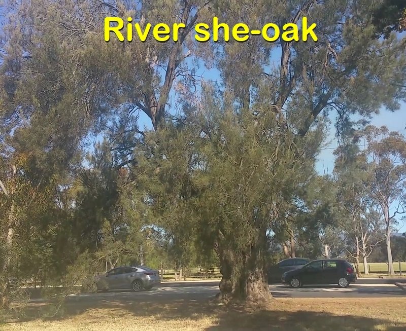
River she-oak tree off Medindie Rd in Bragg Park / Ngampa Yarta (Park 5)
(b) River She-Oak
On the edge of Medindie Road is a river she-oak, which is easily over one hundred years old. Often confused for a pine, it is actually a flowering casuarina. The genus casuarina derives its name from the word for cassowary, and it’s easy to see the similarity between the she-oak’s foliage and the cassowary’s feathers.
Species related to this one have been found in the fossil record dating back to the time of Gondwanaland. Old specimens like this one are important to native birdlife: the cone-like fruit are a source of food for black cockatoos; rainbow lorikeets and finches eat the seeds; while willy wagtails, butcher-birds, and peewees (magpie larks) favour the she-oak for nesting.

Canary Island pine tree off Lefevre Rd in Bragg Park / Ngampa Yarta (Park 5)
(c) One Canary Island Pine
Also in sight on the opposite side of the Park, on the edge of Lefevre road, is a Canary Island Pine tree. It is the same species that you saw at the beginning of the walk off O’Connell street at North Adelaide.
(d) Many Norfolk Island Pines
Look further along Lefevre Road to the north-west, and you will see many Norfolk Island Pine Trees lining both sides of the road.

Norfolk Island pines on either side of LeFevre Road, separating Park 4 (on the left) from Park 5 (on the right).
Back in 1921, the Adelaide City Council approved the planting of 44 Norfolk Island Pines along Lefevre Road, at a cost of 70 pounds. This original planting has since been maintained with additional plantings and the replacement of dead or unhealthy trees. You can see that the trees on the other side of the road (in Park 4) are much taller than the trees on this side in Park 5. This means that most of the original 1920’s trees on this side of the road would have died and been replaced more recently.
Now walk over to Lefevre Road and onto the bicycle path. Head north towards the public toilet.

8. Re-alignment of Le Fevre Road
Parks 4 and 5 haven’t always been this shape and size. Up until the 1960’s Lefevre Rd was straight, not curved.
The road re-alignment in the 1960’s improved traffic congestion and made Bragg Park / Ngampa Yarta (Park 5) a little larger than it had been. Conversely, it shrunk the size of neighbouring Reservoir Park / Kangatilla (Park 4).
The original path of Lefevre Road would have gone straight through where the toilet block now stands.
An aerial photo of Parks 4 and 5, taken in 1935, showing Lefevre Rd in a straight line, not curved as it is today ~ Creator: City of Adelaide
Pause on the path and look at the vegetation around you.- especially on this side of Lefevre Road.
From the 1850s to the 1870s, this Park - Bragg Park / Ngampa Yarta (Park 5) - was used mainly for agistment of livestock, grazing and firewood collection. Within two decades of European settlement, (by the 1860’s) most of the native vegetation had been removed.
In the late 1870’s the City Council decided to try rectifying the barren landscape.
They recruited a forestry expert from Scotland, named John Ednie Brown.
In 1880, Mr Brown produced a city-wide report addressing the capacity for renewal of Park Lands vegetation. This Park, however, was unfavourably regarded in Mr Brown’s report.
His 1880 report noted the thin soil here, with a strong layer of limestone beneath. This perhaps accounts for the mostly stunted nature of the trees within Ngampa Yarta.
At the beginning of the 20th century, a new city gardener August Pelzer undertook major replanting in some parts of the Park Lands. However, these northern Park Lands were largely neglected (at that time) in favour of the south and eastern Park Lands.
It wasn’t until the 1960s that the City Council engaged in major replanting, both trees and understorey, the majority of which were natives.

An aerial photo of Parks 4 and 5, taken in 2018, showing Lefevre Rd in a straight line, not curved as it is today ~ Creator: City of Adelaide
You can see river she-oak, sweet scented hakea, and weeping myall among the native species here.
From this point, just cross Lefevre Road and enter into Park 4.

9. Park 4: naming & and Park Lands trail
"Kangatta" or native cranberry
Crossing Lefevre Road takes you from Park 5 into Park 4. Park 4 is called “Reservoir Park / Kangatilla.
The name ‘Reservoir Park’ refers to an underground reservoir which you will come to near the end of the trail – not far from where you started this walk.
The Kaurna name for the Park “Kangatilla” “comes from the Kaurna word “Kangatta” a berry identified as native food source, possibly the native cranberry.

"Kangatta" or native cranberry
The area around Park 4 is said to have been used by the Kaurna people (before European settlement) as an intermittent camp ground, and good hunting area.
The City Council estimates that there are more than 10,000 visits to this Park every year.

A portion of the Park Lands trail in Reservoir Park / Kangatilla (Park 4)
This red path is part of the Adelaide Park Lands trail, pedestrian and cycling route, which crosses Park 4 in a roughly east-west direction.
It provides a link between Park 2 (to the west) and Park 5 (to the east) and forms part of a peaceful alternative route through North Adelaide towards the city.
Keep walking westwards along the red path, until the path does a left-hand bend, and stop at the bend.

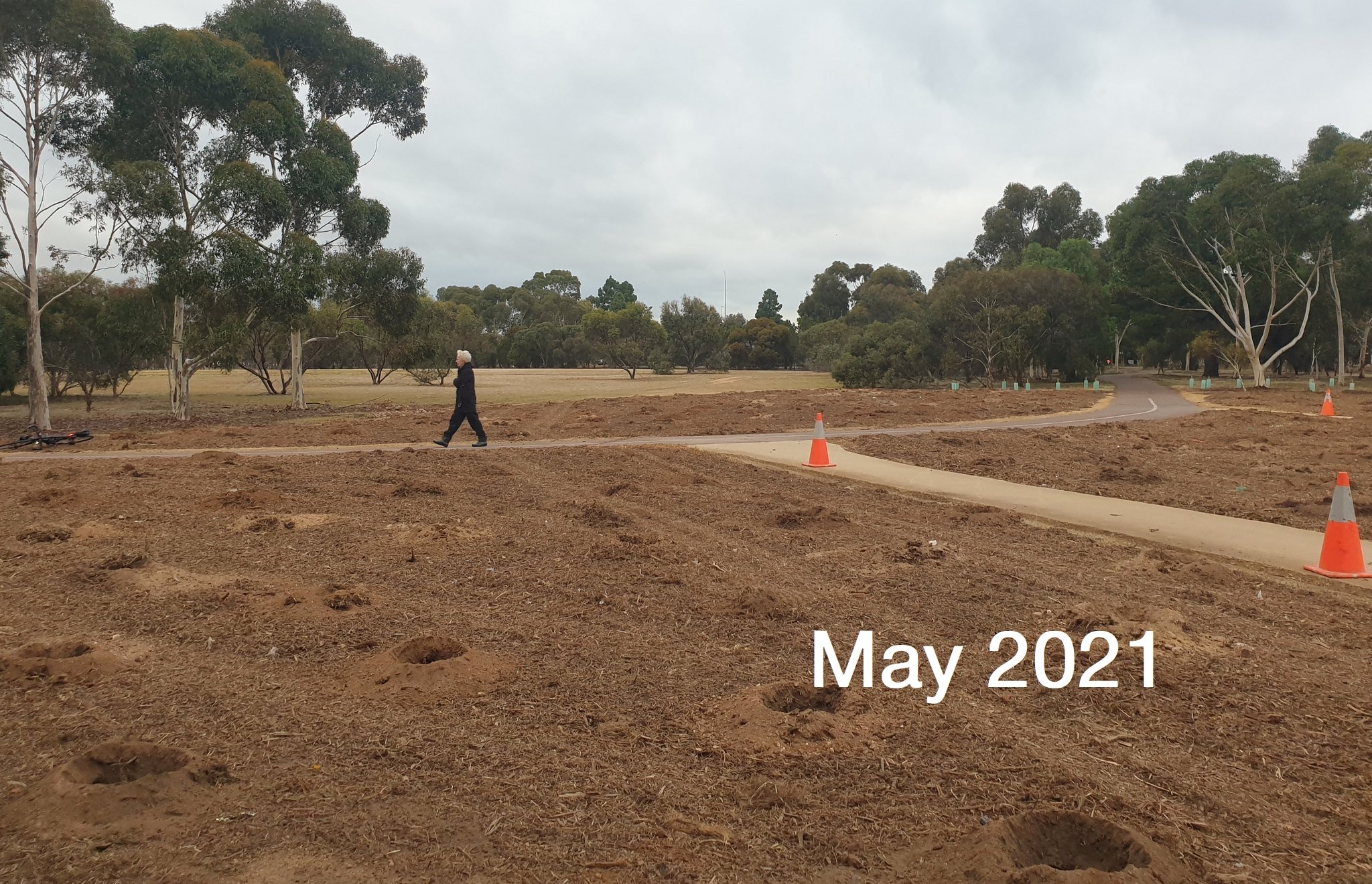
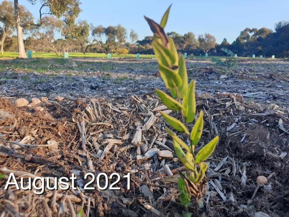
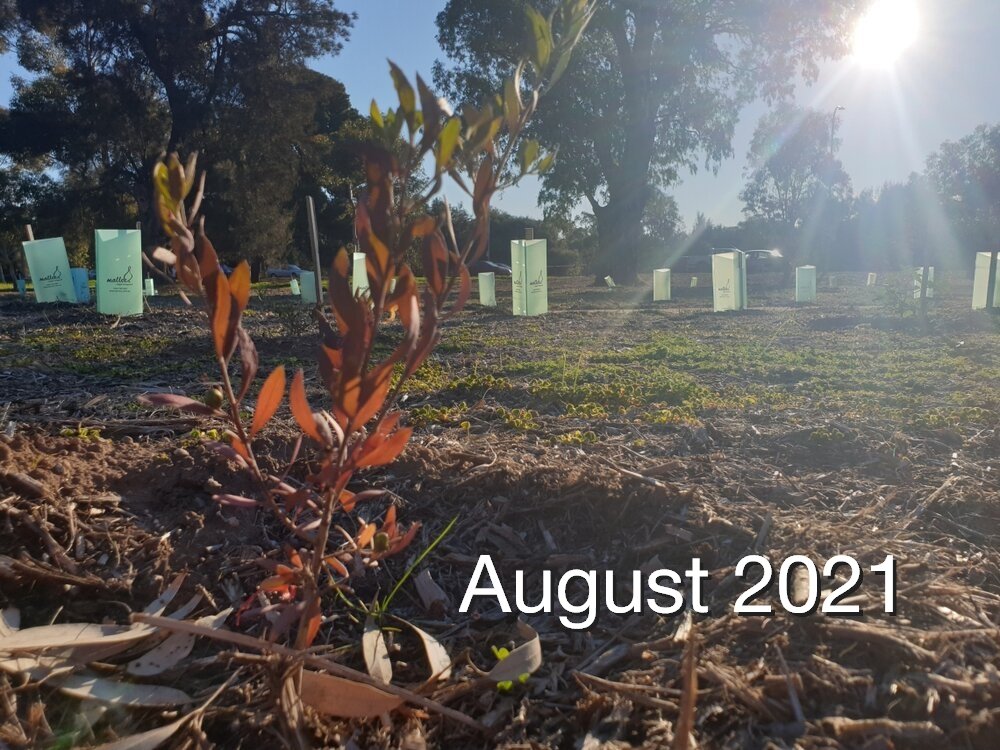
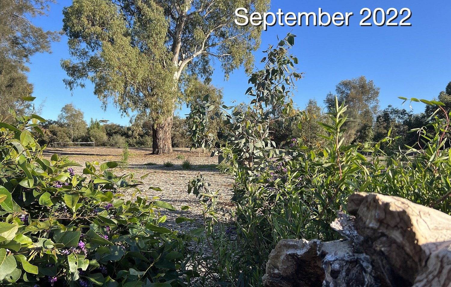
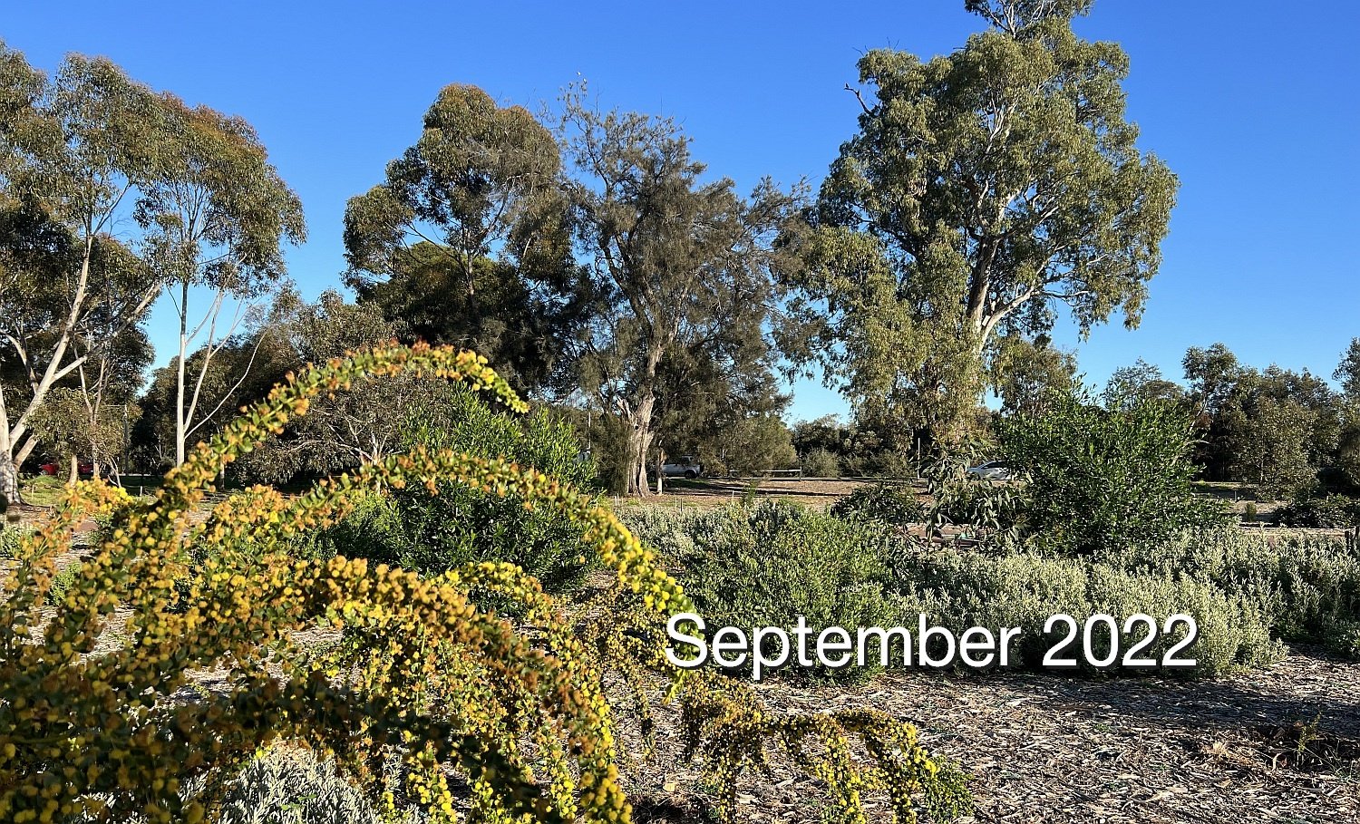
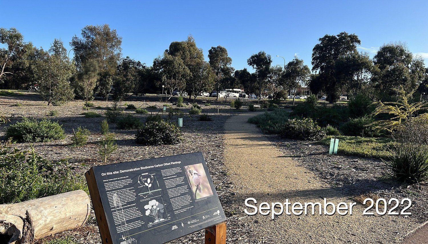
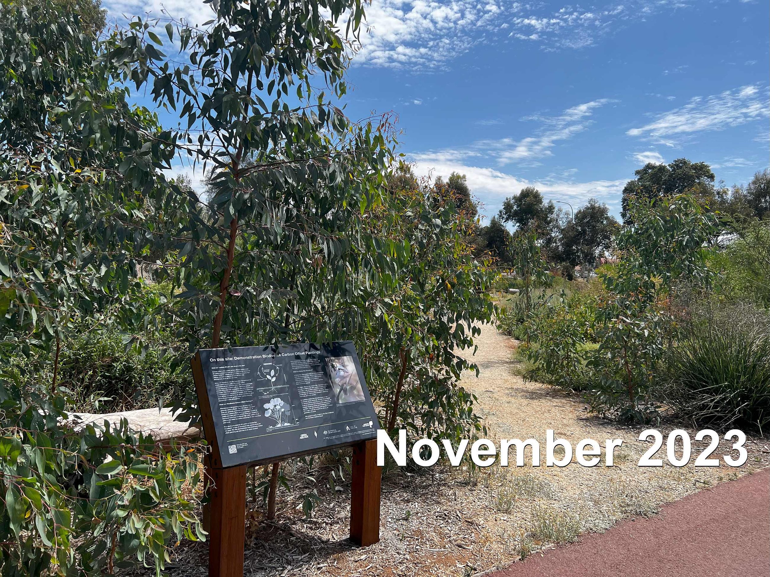
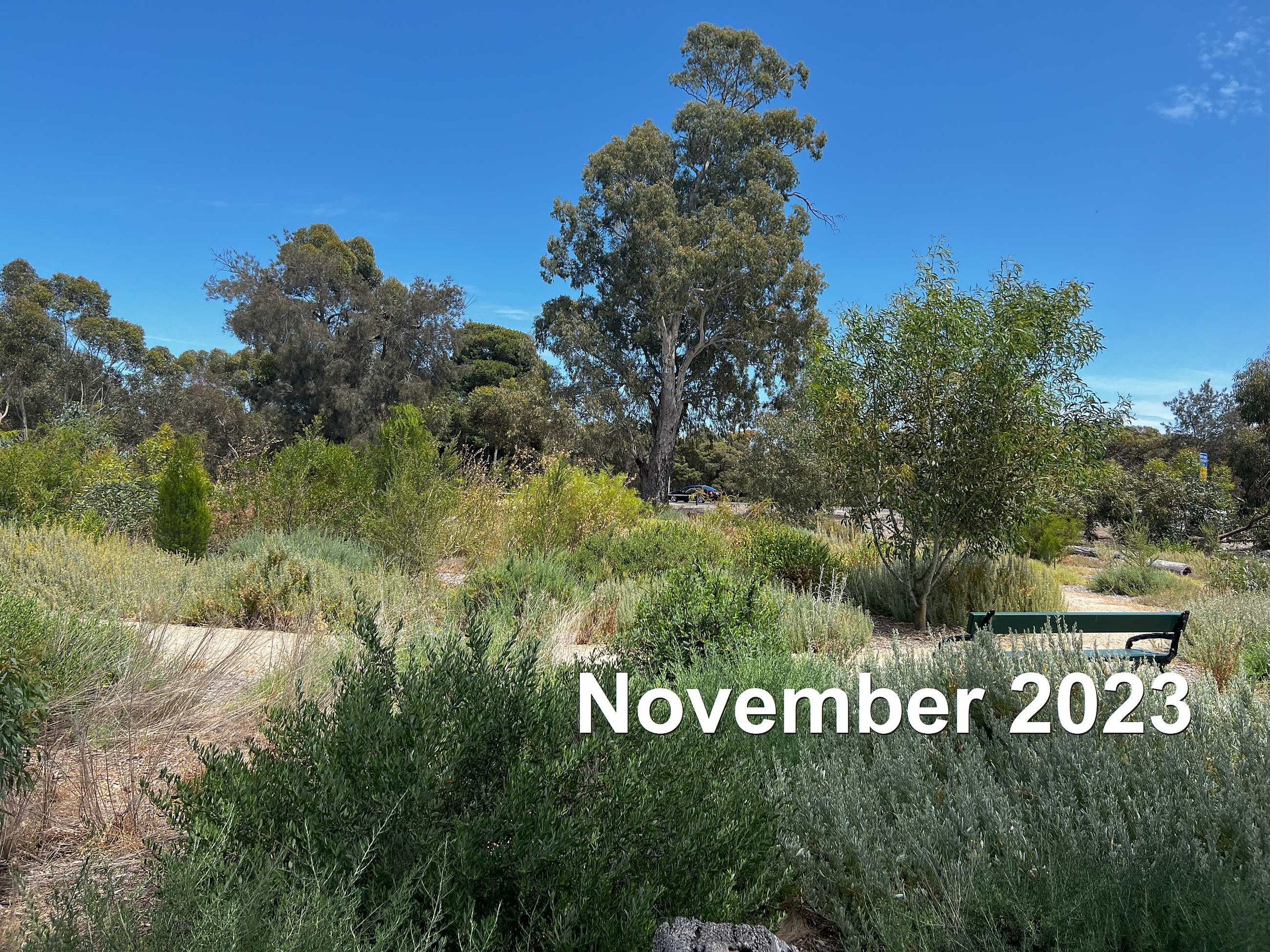
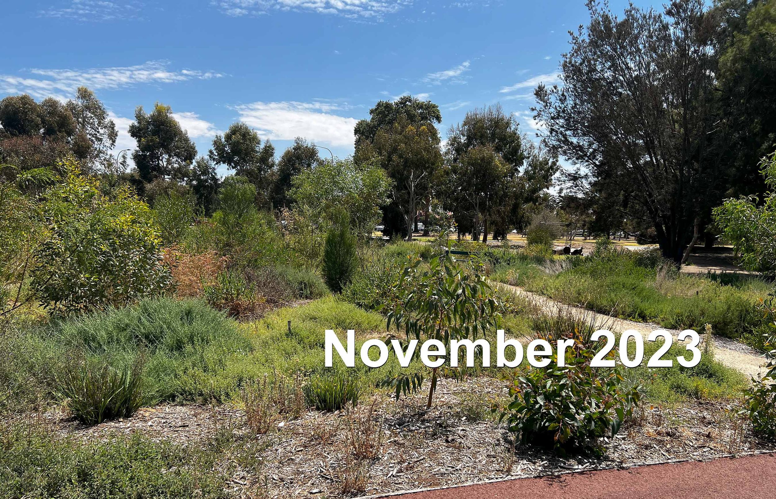
10. Carbon offset planting
This area of about 3,000 square metres has been planted with more than 500 local native tube-stock seedlings.
It is growing into a "mallee box woodland" - the type of vegetation that was found here before Europeans arrived in the 1830's.
Here’s how it’s been transformed since 2021:
This area of native vegetation was, for more than 90 years, the home of a croquet club with its own building.
The Fitzroy Croquet Club was established here in 1910. It preceded the establishment of the South Terrace Croquet Club, a year later in 1911. The South Terrace club still exists in Park 17.
For about 100 years, from the 1860’s to the 1960’s, croquet was a very popular game especially at first among the upper-class in Adelaide, many of whom had migrated from the United Kingdom. It was a game that reminded them of the old country.
Many of these people were able to build substantial homes in the Fitzroy, St. Peters, Medindie and Walkerville areas, just north of the city. A lot of these homes had their own courts, and social games, but the enthusiastic players established a club here in Park 4, with the City Council’s approval.
Croquet was especially popular among women. A newspaper cutting records that in 1934 there were 1,300 registered players in South Australia, only six of whom were men.
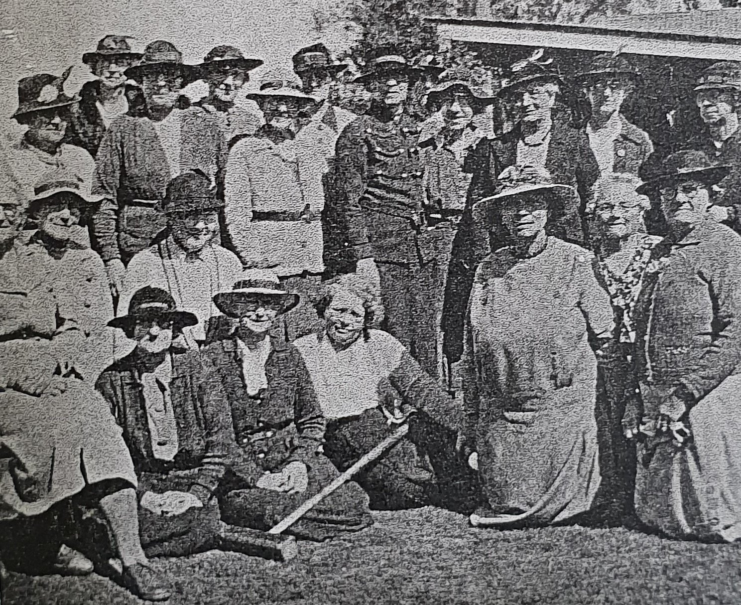
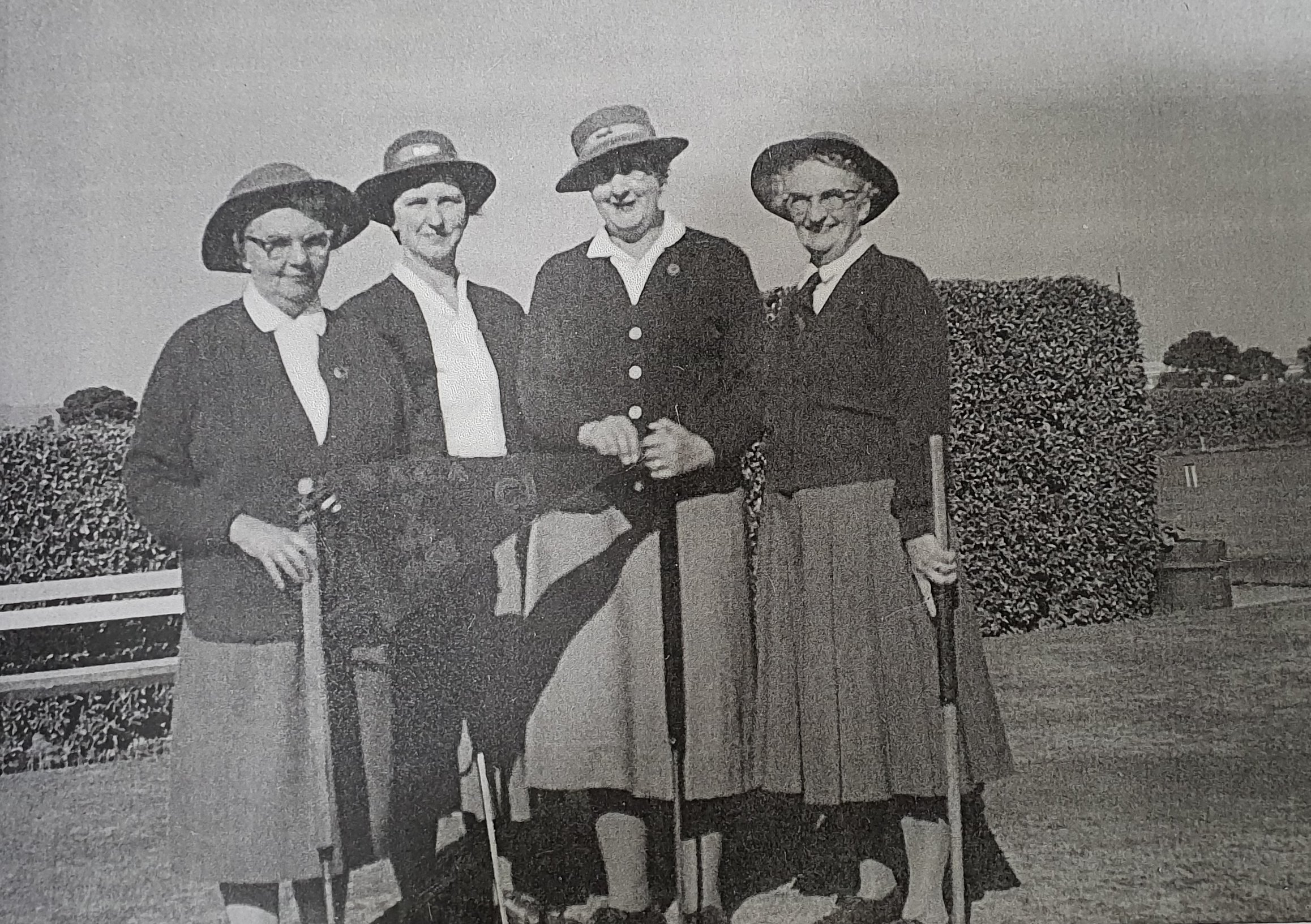
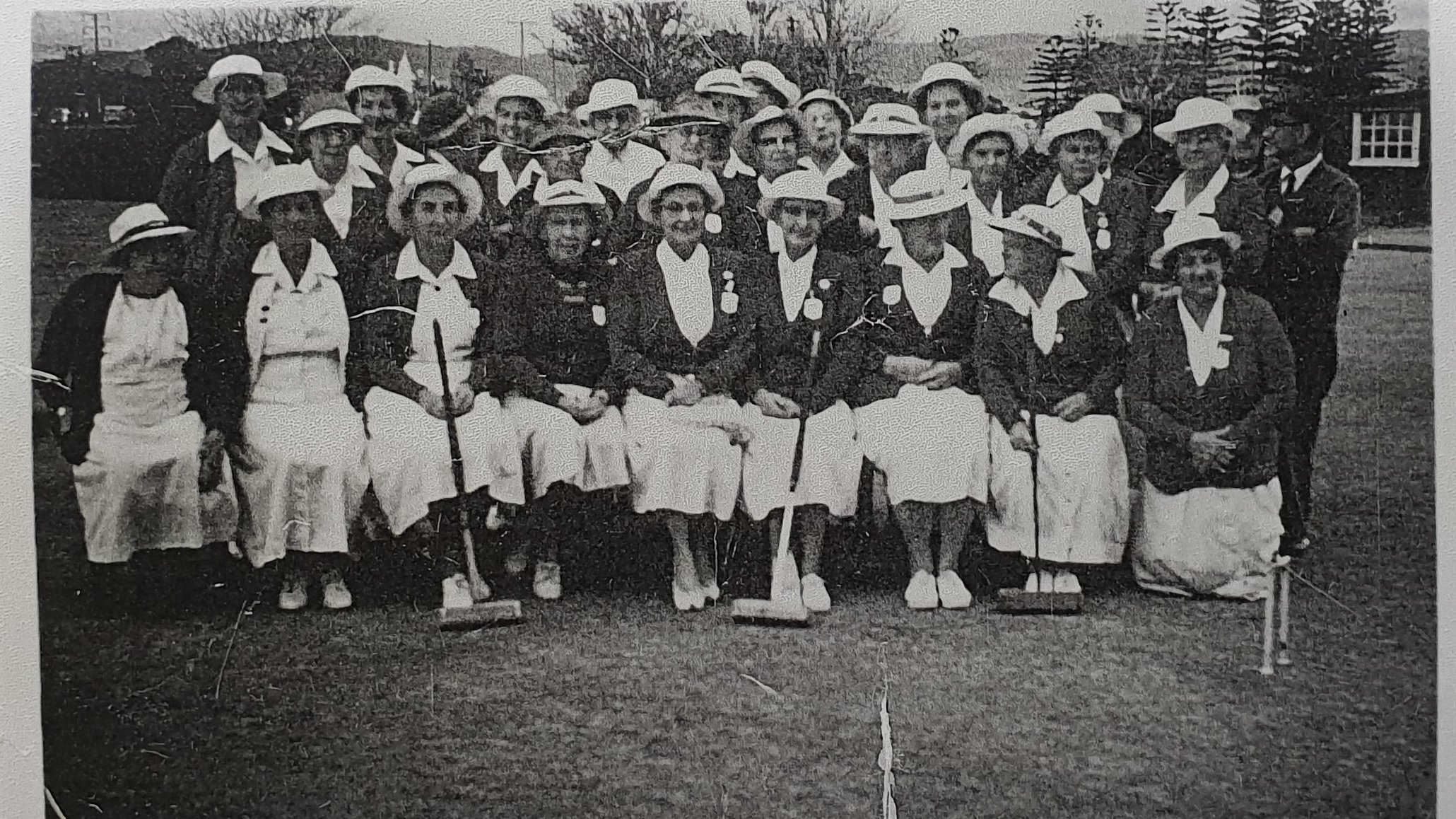
Historical photos from the Fitzroy Croquet Club. Source: State Library of SA
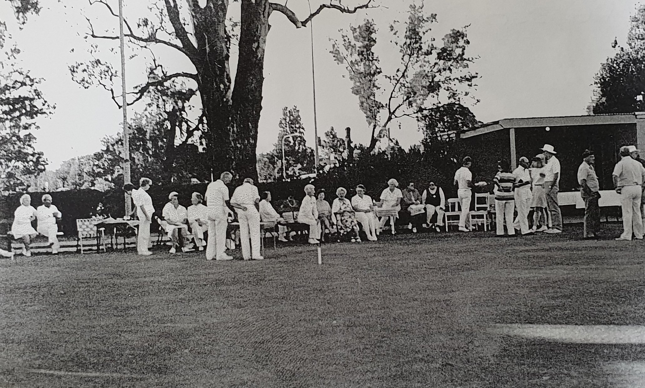
The Fitzroy Croquet club had its last playing day here in 2002 attended by the then-Lord Mayor, Jane Lomax-Smith, and the building was removed in 2004. Its replacement, the North Adelaide Croquet club, has its facilities now in Prospect.
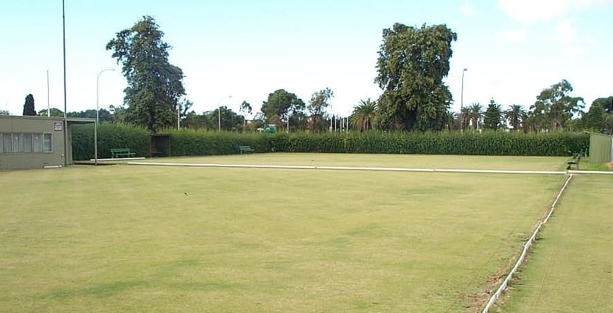
The former Fitzroy Croquet Club, 2002, at the time of the Club's last game here. The building was removed in 2004. ~ Source: State Library of SA archives ~ Creator: Fitzroy Croquet Club
If you look over towards Main North Rd you can see a large gum tree. That is a River Red Gum, one of the oldest anywhere in the Park Lands - probably planted around 1850.
From here, turn around and go back the way you have come for just a short distance. About 50 metres from here, back along the red path, you will come to a dirt road which crosses this sealed path. Turn right onto the dirt track and walk south for about 50 metres until you are in the centre of Reservoir Park. Stop at the stobie pole with a street light.

11. Two former sporting ovals
For decades, there were two sporting ovals here in Kangatilla. However, early in the 21st Century a decision was made to devote much of this Park to re-vegetation and increased biodiversity.
From this point, in the centre of the Park you can see each of the former sports grounds.

Two former sporting Ovals in Reservoir Park / Kangatilla (Park 4) as they were in 2007 ~ Creator: Google maps
To the west you can see one of the former sports grounds which has been left predominantly as open space.
To the east you can see the other former sports ground which has been substantially re-vegetated. It’s hard to imagine that both of these areas were functioning as sports grounds, with a central cricket pitch in each of them, as recently as 2007.
From this point, walk westwards, directly across the former sporting oval towards an area that has been fenced off with tall black metal fencing.

One of the two former sporting Ovals in Reservoir Park / Kangatilla (Park 4)

12. Electricity substation
Behind the black metal fence is an electricity substation which has occupied this site since the 1960’s.
In 2007, the City Council commissioned a cultural and heritage evaluation of the Park Lands. The assessment of Park 4 included this advice:
Expansion of the ETSA substation would be “inappropriate.” It should “removed from the Precinct and the area returned to Park Lands usage.”
However that advice was not acted upon. In 2011 the substation was extended and another 925 square metres of Park Land was taken.

Electricity substation in Reservoir Park / Kangatilla (Park 4) of the Adelaide Park Lands
In 2016, the then Planning Minister John Rau changed the development plan for the Adelaide Park Lands as it concerned “infrastructure”. Any project described as “infrastructure” was from then on classified as “complying” development.
This meant that there was no need for public utilities to undertake any public consultation, and no public comments could be taken into account when planning authorities were considering more infrastructure like this.
Now walk south along the fence line until you come to a brick building.

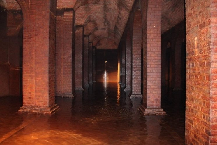
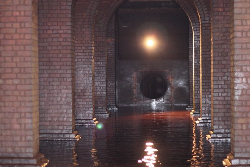
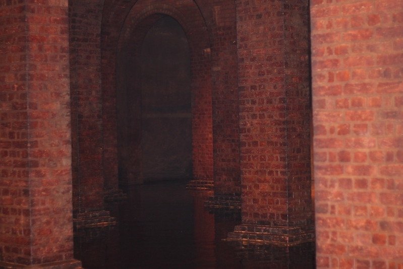
13. Underground Reservoir
Inside the underground 1878 reservoir in Reservoir Park / Kangatilla (Park 4) ~ Creator: SA Water
Alongside the red brick building is a large earth mound. Hidden underneath this earth mound is an impressive feat of engineering that dates back to the year 1878.
It is a 4.7 megalitre water tank, a reservoir, that is still in use more than 140 years after it was installed. In fact, it forms a critical part of the Adelaide Water supply network, supplying approximately 100,000 people throughout Adelaide.

Diagram of the reservoir site in Reservoir Park / Kangatilla (Park 4) of the Adelaide Park Lands ~ Creator: SA Water
It was originally constructed in 1878 and linked to the Thorndon Park reservoir in Adelaide’s north-east. At the time, there was a “Hydraulic Engineers Office” that had responsibility for water services and assets for South Australia. The tank’s initial role was to service and increase the pressure for the Port Adelaide area, which had water mains connected a few years earlier in 1865.
The increase in pressure, from this tank, allowed for the improvement of the sewerage system in Port Adelaide.
The tank is constructed of brick with an arched roof, supported by 48 columns, with a concrete floor and soil mounded over. The tank also includes drains to dispose of water that pools in the arches. Since 1878, little has changed to the internal structure of the tank.
In 2017, SA Water hired contractors to improve drainage above the tank roof and treat some cracks in the tank structure. Having done that work, the tank was considered good to continue in service for decades more.
The red brick building is used for adding chlorine to the water tank. Chlorine is a disinfectant. Its use safeguards public health, by killing disease-causing pathogens, such as bacteria, viruses, and protozoans.
The tank has been provisionally entered on the State Heritage Register. The South Australian Heritage Council noted:
“The quality of its design and construction were remarkable for its time and function; the utilitarian building being constructed using piers and arcades more commonly seen in grand neoclassical structures, creating a ‘cathedral-to-water’.”
Now walk further south, until you rejoin Barton Terrace East.

14. Pine trees and bicycle path in Park 4
On the southern edge of Reservoir Park is a shared-use bicycle and pedestrian path, constructed in 2017.
There are a number of “exotic” tree plantings alongside this pathway. They include Aleppo Pines, Canary Island Pines, and a grove of Hackberry trees.

Pine trees on the southern side of Reservoir Park / Kangatilla (Park 4)
From this point, turn right which brings you back to the starting point of this trail, on the corner of Barton Terrace East and O’Connell Street.
Optional: download and print a tri-fold leaflet, i.e. a double-sided single A4 page, with a brief summary of this Trail Guide: (PDF, 4.1 Mb)
All of our Trail Guides and Guided Walks are on the traditional lands of the Kaurna people. The Adelaide Park Lands Association acknowledges and pays respect to the past, present and future traditional custodians and elders of these lands.

