

Take the trail
Start at the corner of Peacock Road and South Terrace, near the tram stop.
This Trail is on the traditional land of the Kaurna people. It’s 1.8 kilometres and it will take about 90 minutes to complete.

Start this trail at the corner of South Terrace and Peacock Road.
There are 22 stops on this Trail. It’s 1.8 kilometres long and will take about 90 minutes to complete. Walking instructions are designated by bold type at the end of each of the 22 stop descriptions.
Optional: download and print a tri-fold leaflet, i.e. a double-sided single A4 page, with a brief summary of this Trail Guide: (PDF, 1.5 Mb).

1. Introduction & naming
Start this walk at the corner of Peacock Road and South Terrace, near the tram stop. This is the north-eastern corner of Veale Park, also known as Walyu Yarta – or simply Park 21.
Park 21 is a rectangle - bounded by South Terrace, Greenhill Road, Peacock Road and Sir Lewis Cohen Avenue and is 31 hectares in size.
This means that in the context of the whole Adelaide Park Lands, it’s only about four per cent of the total area.
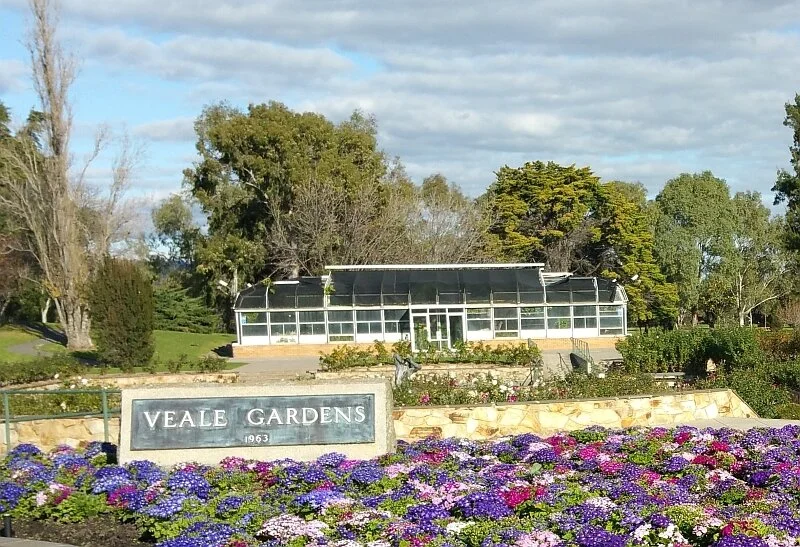
The English name of this Park, Veale Park, is in honour of former Town Clerk William Veale.
Veale Park refers to the whole of the Park – from South Terrace to Greenhill Road. The well-known Veale Gardens represents just the northern part of Veale Park, alongside South Terrace.
William Veale was an Australian Lieutenant in World War One, and a Commanding Officer in World War Two.

William Veale ~ Source: Australian War Memorial photo 097385
After the war, he became the Town Clerk of Adelaide from 1947 until 1965. Town Clerk was what we would now call Chief Executive Officer.
On a study tour of local governments in Europe and North America in 1957, Mr Veale found inspiration for the future development of the Park Lands.
Veale Gardens were built in 1963 to William Veale’s design. It was only in September 2017 that the City Council extended the name ‘Veale Park’ to the entire area of Park 21, extending to Greenhill Road.
The other name of this Park, in the Kaurna language, is “Walyu Yarta” which means the area where you find the ‘Walyu’ root. Walyu is a native edible white root, similar to a radish, that would have been a source of food to the Kaurna people.
From the corner, walk along the path towards the large building – the Adelaide Pavilion.

2. The Pavilion
.
This building, owned by the City of Adelaide, was originally named the Alpine Restaurant. It was adapted from a design of a Cincinnati restaurant that Town Clerk William Veale had seen in an American magazine.
It has an unusual roof – what architects would call “a hyperbolic paraboloid” which means curves made of straight lines.
This style of roof was chosen so the building would blend in, with its surrounds, in what was supposed to be evocative of an ‘Alpine’ style.

Pic: Adelaide City Photo archives, circa 1963
At the time of its opening in 1963, the building attracted some criticism. One critic remarked that “If the new building is as restless inside as it appears outside, it will be difficult for anyone to sit long enough to complete a meal, let alone digest it.”
The restaurant, nevertheless, proved incredibly popular; so much so that it in the 1960s it was often difficult to gain a table.
Making things even more difficult for its enjoyment of the general public, were the strict dress codes – a reflection of stuffy Adelaide attitudes of the time - which turned people away for even the slightest fashion faux pas.
It has long stopped trading as a restaurant. Since 2003 the building has been used as a private function centre, catering to corporate events and the many weddings that occur in Veale Gardens.
From here, walk along the path that curves along the south side of the creek.

3. Creek and grottos
Town Clerk William Veale initially described his plan for this area as an ‘Alpine Garden’ to match the Alpine restaurant. He quickly regretted this name, as critics, newspaper cartoonists and even his own Lord Mayor James Irwin found mirth in the pretension of a ‘Alpine’ setting in Adelaide. Within a week, Mr Veale had backtracked, insisting the garden was from then on to be known as a rock and water garden.
Water was always going to be a major part in Mr Veale’s vision for the garden. This creek, though artificial, provides home to water birds and brings serenity in its meanderings.
Veale Gardens features not just the creek, but also a series of six grottos, creating recesses of mystery and calm. In one of the grottos on your left you will see a fountain. In another one you’ll see a waterfall. Each grotto was intended to be different to each of the others, but the overall intention of the design was to create “a quiet tranquil place of beauty”.
The grottos are humbler than Mr Veale had intended. His ambitions were to create water effects that in his words, shouldn’t be “too tame”. His proposals included something called a “dolphin display”, where jets of water would appear to leap between ponds. Another display would have had a jet of water spurting almost three metres into the air.
Mr Veale also intended to have a grotto that was 10-metres long, a floral clock (and brought a consultant from Scotland to design and build it), as well as a strobe-lit waterfall. However his plans were scaled back to the modest water features you can see today, and the effect is probably more restful than it would have been in Mr Veale’s vision.
The water for this stream was originally pumped all the way from Torrens Lake.
From here, cross over the creek and walk up to the sandstone sculpture pictured below.


4. The Couple
Between the creek and South Terrace you can see a sandstone sculpture of two human figures.
This sculpture, named ‘The Couple’, was created in 1962 by Berend van der Struik who had emigrated from the Netherlands five years earlier. It was one of the earliest features installed in Veale Gardens.

The sculptor had some back luck with his creation. After 30 hours of work on the piece, the sandstone cracked. He received permission to start again with another piece of sandstone, purchased from Maroubra in Sydney.
The sculpture depicts two early settlers, a man and woman. When it was unveiled in 1962 predictably it attracted controversy. Some people questioned its artistic merit, while others doubted the value of Council spending on any public art. The Lord Mayor of the time was simply quoted as saying: “you either like them or you don’t”.
At the time, a cartoon appeared in the Advertiser with an elderly couple wearing coats, hats and glasses saying, “well, we’re a couple, but I fail to see the resemblance”.
Unfortunately, sandstone is not an ideal stone for an outdoor sculpture and it has weathered over the years, losing some of its original sharper features.
From here, walk over to South Terrace and stand underneath one of the huge river red gums.

5. River Red Gums
On the northern side of Veale Gardens, bordering South Terrace, there are several imposing eucalyptus trees.
These are River Red Gums, and they are planted at intervals along the edge of Veale Gardens providing shade for the plants and people below.
This species can live as long as one thousand years, though these ones are quite young, having been planted in the 1920s or 30s. They were mature trees long before Veale Gardens was landscaped in the 1960s.
Their branches create homes for many birds and some wildlife, such as possums.
From here, walk a little further west, to a wooden pergola covered in vines.

6. Mabuhay Pergola
About 30 to 40 metres west of 'The Couple” is a wooden structure covered in wisteria vine. This is known as the Mabuhay Pergola.
The word “Mabuhay” is a greeting in Tagalog, the language of the Philippines. It literally translates as ‘Live’, (as in “alive”) but means something closer to the Spanish ‘Viva!’ As such, the Mabuhay Pergola welcomes you to enjoy a long life. This pergola was donated in 1978 by Philippines Timber producers and local importers.
It's made of Philippines mahogany and another timber, a critically endangered hardwood of south-east Asia known as Apitong. Chinese wisteria grows over the pergola.
In spring, the hanging purple clusters of its flowers give off a sweet perfume.
Now, go back across the creek to one of the grottos, bordered by a rock wall.

7. Shallow pool of death
Near the bitumen footpath is a grassy area in front of a small rock pool, one of the grottos that is set back from the path.
This pool was the scene of a murder.
In April 2017, 67-year-old Helen Dansie (who was wheelchair bound after a stroke some 20 years earlier) died in this pool . Mrs Dansie drowned in water which was said to have been only 1.1 metres deep.
Three months later, her husband was charged with her murder. 68-year Peter Dansie pleaded not guilty. He said it was an accident. He was committed to stand trial in the Supreme Court, late in 2018. After a mistrial he was eventually found guilty of murder in December 2019. The Dansie's son Grant Dansie gave evidence in the trial against his own father. Evidence at the trial indicated that Dansie senior regarded his disabled wife as a financial burden. He was sentenced to life in prison, with a non-parole period of 25 years.
In August 2022, the High Court ruled that the case be re-opened with a fresh appeal to be heard in the SA Court of Criminal Appeal. In March 2024, Peter Dansie lost that appeal. His conviction was upheld and his life sentence was confirmed. Two months later, in May 2024, he died in prison.
Walk along the path a little further until you come to another creek crossing,. Turn right here, cross the creek and approach a sundial on a pedestal.

8. Sundial
This sundial sits on a pedestal of marble. It was donated by the Symon family in 1964 from their garden in Upper Sturt.
The donation from the Symon family in 1964 was in memory of one of their ancestors. It commemorates Sir Josiah Henry Symon a distinguished lawyer and parliamentarian, who helped draft the Australian constitution.
The sundial is a reproduction of one owned by Sir Walter Scott, the Scottish novelist and poet of the late 18th century & early 19th centuries. He is most famous for writing the line “”Oh, what a tangled web we weave, when first we practice to deceive!”
There are Greek letters around the top of the sundial pedestal. Translated, the phrase means: “The Night Cometh”.
At this point, walk around the rose beds and descend the steps into the sunken rose garden.

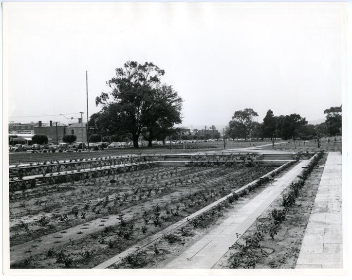
9. Sunken Rose Garden
Before 1963, weddings in Australia could be held only in a church or a registry office. Outdoor weddings were not permitted, anywhere in Australia.
Coincidentally Veale Gardens was built in the same year, 1963.
After the law changed in 1963 to permit outdoor weddings, it took another ten years for the first wedding to be held here in Veale Gardens. That was because the City Council would not permit any part of the Park Lands to be used for weddings. Fortunately, that policy changed in the 1970s. Since then, this sunken rose garden has been one of the most popular venues in Adelaide for weddings.
At its inception, this garden contained 1,400 roses of more than 50 different varieties.
Since the 1960s the City Council's Director of Parks and Gardens and its head gardener have planned and supervised the planting of the roses to get an attractive blend of colour and fragrances.

From the sunken rose garden, walk a few paces westwards to see four concrete lion heads on a wall.

10. Site of former conservatory
On the back wall behind the pond, you will see the heads of four concrete lions, gushing water from their mouths.
From the 1960s until 2013 they were not lions, but four native animals, in bronze. The sculptures first put there were of a kangaroo, a platypus, a koala, and a quoll. For these to be made, specimens were borrowed from the South Australian Museum and delivered to the Town Hall. The modeller, Mr Logger, used the real specimens to create plaster models that were later cast in bronze. However the native animal heads were frequently targeted by vandals, and the City Council eventually removed them and replaced them in 2013 with the generic concrete lions.
Three years later, in 2016, the former Veale Gardens conservatory was demolished. The former conservatory was built in the 1960s not long after the Pavilion was built, and by the same builder, Ezio Moroni (1925-2006). The conservatory was used by gardeners for seasonal displays of plants and flowers.
In the 1960s a pergola led up to conservatory. However the former conservatory site now is a level patch of grass. To the south, you will see two pecan nut trees which can attract flocks of corellas.
From this point, walk across the flat grassed former conservatory site, and look southwards at the mounds and hills behind the creek.


11. Mounds behind the grottos
.
The hills or mounds behind the creek did not exist before the 1960s. This area was originally completely flat. The hills which host the Adelaide Pavilion, the grottos, and the grove of trees on top were created in the 1960s. They needed 70,000 cubic metres of soil, to be carted from other places within the Park Lands, where excavation works had been undertaken.

Similar landscaping work was being done at about the same time in Rymill Park and in Bonython Park.
Excess soil from each of those sites was brought here to create these hills or mounds.
At Rymill Park they were also excavating a rubbish dump off Bartels Road in the late 1950s.
The Veale Gardens mounds changed the previously flat landscape and they provide the garden with its characteristic form.
From here, go back down the steps or ramp, towards South Terrace to look at the statue and fountain of the god “Pan” in a square pond.

12. Statue of Pan and flower bed entrance
In front of you is a fountain containing the mythical god, Pan, as its centre piece. Councillors at a meeting in 1962 talked of wanting this to be “like fountains you see in Vienna”. Pan was sculptured by well known artist John Dowie. Unfortunately, during its construction, Pan fell and was damaged, forcing Dowie to redo parts of the statue. It was installed in 1963.
John Dowie was also the sculptor of the ‘Three Rivers’ fountain in Victoria Square and the statue of Lewis Carroll’s “Alice” in Rymill Park
In front of Pan, bordering South Terrace is a garden bed that (for most of the year) is a riot of colour with annual flower plantings; such as pansies, or alyssums. This is the official entrance to Veale Park.
The bronze name plaque is in the same style as the ones marking “Rymill Park”: and “Bonython Park” as all three Parks were landscaped at a similar time in the early 1960s.
From here, climb the steps or ramp and head a few metres west towards the next statue in the centre of circular rose beds.

13. Adelaide-Qingdao rose garden
This rose garden is dedicated to the sister city relationship between Adelaide and Qingdao (pronounced: Ching-dow”).
Qingdao is a city in north-east China, and regarded by some as one of the most beautiful and clean cities in China. Qingdao was chosen as a sister city because of its similarities to Adelaide and the expected positive impact on trade relations between the two cities. One of China’s most popular alcoholic beverages –Tsingtao beer - is brewed there, and relies heavily on imported South Australia barley.
The feature of the Qingdao rose garden is the statue “Song of the Wind” installed in February 2018. A matching “sister” of the sculpture is located in a Park in the City of Qingdao.
The two statues are said to “echo each other” with the song of the wind, across the Pacific, bonding the friendship between Adelaide and Qingdao.
Continue walking westwards, along the shady path towards the traffic lights.
A short distance past the Qingdao rose garden is a patch of lawn, which was the site of a former timber sculpture.
Made of Australian Jarrah, it was called a ‘Hypar shelter’. It was made up of two hyperbolic parabaloids (curved shapes made from straight lines), emulating the shape and style of the Pavilion roof where this Trail Guide commenced.
It was removed in 2003 as the timber had deteriorated.
From here, keep walking westwards along the path until you come to a road, Sir Lewis Cohen Avenue.


14. Sir Lewis Cohen Avenue
At the traffic lights you are at the north-west corner of Veale Park / Walyu Yarta. The western boundary of this park is Sir Lewis Cohen Avenue.
Heading north, this road becomes Morphett Street and goes right through the city and North Adelaide, passing three of Adelaide’s six squares on the way: Whitmore Square, Light Square and Wellington Square.
Sir Lewis Cohen Avenue was opened in 1906, severing this Park 21 from its western section across the road, which then became known as Park 21 West. Sir Lewis Cohen was four times elected as Mayor of Adelaide – in four separate periods – between 1889 and 1923.
He was also a member of State Parliament for 10 years, and Chief Magistrate for seven years.
Turn left here and walk southwards along the edge of the Park bordering Sir Lewis Cohen Avenue, until you come to a dirt road into the Park.

15. Old Access Road
This access road was closed in 2007. For many years before that it was a well-known beat for gay men.
Until 1975, male homosexual acts were was illegal in South Australia, and police often patrolled known beats with the intention to arrest, entrap, or worse. Even after decriminalisation in 1975, the remaining cultural stigma of homosexuality forced many to continue to meet in secret after dark, and put themselves at the mercy of those who would harm them. Bashings were common, and victims would find little help or support from authorities.
In December 2020, South Australia became the last State in Australia to abolish the so-called ‘gay panic’ defence which used to be available to accused persons to get a murder charge downgraded to manslaughter.
From here, cross over the old access road to see a plaque embedded on a rock just off Sir Lewis Cohen Avenue.

16. Rifle butts monument
This plaque marks the site of former rifle butts. These were huge earthen structures used for rifle practice in the 1800’s.
The earliest recorded use of this Park after European settlement was in the training of volunteer military forces. A well-trained militia was seen as an important asset to the colony. A rifle range nearly a kilometre long was set up in the 1860s, which incorporated large rifle butts - a set of four tall mounds made of earth and stone.
The rifle butts were as tall as a two or three storey building. The riflemen shot at them, so they had a large target!
However, the rifle range was not fenced off from the public walking between Unley and the City, nor from the cattle that were still permitted to graze in the Park Lands. There were several reports of near misses. In one case, fourteen-year-old Master Ebworth, was stooping to pick up a piece of wheat. As he stooped, he had his hat knocked off by an errant bullet. At another time, a pedestrian walking past was told by the rifle-butt man that he could safely go on, only to hear the crack of a rifle and whizz of an overhead bullet.
There were no fatalities during this era, but that is probably down to luck, rather than the care and aim of the marksmen.
Concerns over this use of the Park Lands so close to Adelaide’s growing population caused the closure of the range in 1878.
The stones of the butts were carted off to build new cattle sheds on North Terrace, while the mounds of earth were intended to be incorporated as a feature of the park.
However, the mounds were removed in 1903 and the soil used in the planting of trees in the Southern Park Lands.
This park was also used as the site of volunteer military parades during World War Two.
Now, turn around and walk back to the old access road, and stop at the “UAV” sign, pictured below.


17. UAV area
Heading across this open field, keep alert for model aircraft. This is an area where UAV enthusiasts are allowed to fly. “UAV” stands for ‘unmanned aerial vehicle’ – meaning radio-controlled model aircraft and helicopter drones.
This area is one of only two sites in the Adelaide Park Lands where model aircraft are officially permitted. The other site is in the central sports field part of Victoria Park / Pakapakanthi (Park 16).
Sometimes there are drone races held here in Park 21, with the drones weaving around obstacles at high speed.
Now, keep walking east along the old access road until you come to a small garden in the centre of the Park.

18. Walyu Yarta Community garden
The Walyu Yarta Community Garden was the first community garden within the City of Adelaide. It opened in 2009, after five years of lobbying Council by several gardening groups in the South West quadrant of the City.
Some of these groups had been gardening vacant building sites in the neighbourhood. So-called “guerrilla gardeners” had been planting fruit and nut trees in South-eastern city streets.

There was also a gardening group based at the Adelaide South West Community Centre in Sturt Street who had been campaigning for this.
Before anything could be planted here in 2009, soil had to be brought in because the existing soil was contaminated.
Members of the Walyu Yarta Community Garden group hold monthly meetings, deciding what work needs to be done.
An Open Garden Day every year raises funds for the garden.
The Walyu Yarta community garden has around 100 members and supporters, with about 30 regularly working at the garden or turning up for working bees. Children from Gilles Street Primary School often attend the garden and learn about gardening.
The mosaic butterflies were a project involving Gilles Street Primary, members of the South West community and Uniting Communities.
From the community garden head south.
There is no path – just make your way across-country, walking southward across the open field towards Greenhill Road.

19. Re-vegetation area

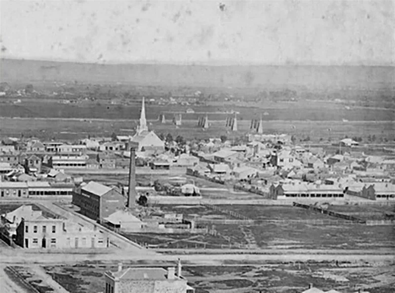
The 1865 ‘Duryea Panorama’ looking south from the Adelaide GPO tower, showing a lack of vegetation in the south Park Lands. The rifle butts are the only feature noticeable in Park 21.
Following European settlement from 1837, the combined effects of grazing and unchecked clearing for timber and firewood had cleared the Southern Park Lands of nearly all native vegetation.
A photograph taken in 1865 shows nothing but a bare expanse south of the city (apart from the rifle butts).
However, ever since the 1880s, re-vegetation has been attempted in several different periods and still continues.
Firstly, to allow larger species to gain a foothold, smaller wattles were planted for shade and protection – which is what we might call today a shelterbelt strategy.
From late in the 20th century, however, there has been an increased awareness of the value of native plants and biodiversity.
Accordingly, there’s been some restoration of a woodlands environment in Veale Park / Walyu Yarta.

The mosaic bench acknowledging a re-vegetation project in 2008.
Walking across this field you will see to your left (to the east) a patch of quite thick vegetation or native bushland.
On the edge of the revegetated bushland, this mosaic bench bears a plaque that acknowledges a re-planting effort in 2008 by a group of young people, endorsed by the Catholic Archdiocese of Adelaide, the then-Premier and Lord Mayor.
Although you are in the open here, it is possible to take a side trip, and investigate one or more of the narrow winding paths through that dense bush.

The locations RCZ2 and RCZ3 on the above map were identified in a 2024 City Council report, as part of the few “Key Biodiversity Areas” within your Adelaide Park Lands.
If you’re walking here in the summer you may notice how dry the grass is, in the southern part of Veale Park. You will likely also encounter thousands of ants, scurrying across dry patches.
This part of the Park Lands can pose a risk of grassfires on days of extreme fire risk.
From here, keep walking south, towards Greenhill Road and stop where you can get a good view of the multiple open sporting fields that stretch across the full width of Veale Park / Walyu Yarta.

20. Cow paddock
Prior to, and after the Second World War, many working class families lived in the south and west parts of the City.
Many of these families owned a family cow, and the ‘family cows’ of the neighbourhood were allowed to graze in the southern Park Lands. Up until the 1960s, most of the Park Lands were fenced to keep stock inside. To enter a park, you would either have to pass through a gate, or climb through the wire fence. The fences were sometimes damaged by cows, as they would put their heads between the wires to graze outside the fence.
During the winter of 1955, one of this Park’s cows became a minor celebrity with repeated stories in The Advertiser newspaper.
The cow was sick, and was being sheltered in a tent and covered in blankets. Its owners, a local couple, tended to the cow night and day to nurse it back to health. The cow couldn’t move due to its poor health and the sodden winter ground. Local residents made regular trips to the cow’s tent, with refreshments, for not only the cow but also its keepers. Eventually a good Samaritan brought in a mobile crane to winch the cow out of the Park Lands and take it to a better shelter.
Up until the 1960s, whenever cricket games were scheduled here, the players had to first comb the field looking for cow dung or “cow pats”. Cow pats that had hardened were easy to remove but recent soft ones put a dampener on the player’s spirits!
It was not unusual for the cows to escape the Park Lands in search of greener pastures. The City Council archives include a letter from a disgruntled resident in 1869, complaining about “cows breaking into my premises and annoying me.” He urged a Council officer to come and “abate the nuisance, as there is still one cow in my yard”. There is no record whether the cow was still there when the letter was received.
At this point, turn left and follow the line of trees towards the east, until you come to a dirt trail.

21. Southern sports facilities
From this vantage point on the dirt trail, you can see sporting fields both to your right and to your left.

The southern end of Veale Park / Walyu Yarta is mostly given over for use by recreational sports.
Next to Greenhill Road, there are two tennis courts behind a wire mesh fence. For many years up until 2022, these courts were licensed by the City Council to the former “Victoria Tennis Club”.
Eastwards, another fenced area contains bitumen courts marked out for tennis, netball or handball.
Just to the north of these fenced bitumen courts are three soccer pitches licensed to the Football Federation of South Australia.
The Federation uses the name SAWSA Park to describe the area, although it is part of Veale Park / Walyu Yarta (Park 21).
Now, turn left onto this dirt trail and head north-easterly. You will be heading back towards the starting point of this trail.

22. Kaurna associations
As you head back towards the Pavilion and the starting point of this trail, consider how much this area has changed since European settlement in 1837.
The Kaurna people lived here for tens of thousands of years before the British and others arrived. The Kaurna connection to the land is still strong today, but the land itself has been radically altered as you would have seen on this Trail.
Many native species of birds and animals remain in the Park Lands.
The South Park Lands (including this Park and the others nearby) have been known to support ten native species of mammal, 150 species of birds, eighteen species of reptiles, and six species of amphibian. There are of course many introduced species as well. Some of them, like dogs and cats, are dangerous to native creatures.
While there are no written records of Kaurna sites specifically in Veale Park / Walyu Yarta, oral evidence suggests that the South Park Lands area generally was regularly used for camping, food harvesting, burial and hunting in the time before European settlement. This ended in the 1860s, when the Kaurna were driven out and their camps burnt.
Accordingly, sociologists report some Kaurna people have in recent decades associated parts of the South Parklands with ‘spiritual danger'.
Optional: download and print a tri-fold leaflet, i.e. a double-sided single A4 page, with a brief summary of this Trail Guide: (PDF, 1.5 Mb).
All of our Trail Guides and Guided Walks are on the traditional lands of the Kaurna people. The Adelaide Park Lands Association acknowledges and pays respect to the past, present and future traditional custodians and elders of these lands.

